Architectural Area & Land Surveying Suite
Land Area & Survey Unit Converter
Convert land plot dimensions across international and regional surveying units: square meters, square feet, acres, hectares, bigha, and guntha.
Primary Area Output
1.500 Acres = 6070.3 m²
Acres, Hectares, Bigha, Guntha
Survey Dimensions
Acres
1.500 Ac
43,560 sq ft/acre
Hectares
0.607 Ha
10,000 m²/hectare
Square Feet
65340.0 ft²
6070.28 m²
Step-by-Step Mathematical Derivation
1.Input Land Area: 1.5 acres
2.Normalized Base Metric Area: 6070.28 Square Meters
3.Imperial Square Feet (1 m² = 10.764 sq ft): 65340.0 sq ft
4.Standard International Acres (1 Acre = 43,560 sq ft): 1.5000 Acres
5.Metric Hectares (1 Hectare = 10,000 m²): 0.6070 Hectares
6.Regional Survey Units: 60.00 Guntha (1089 sq ft) | 150.00 Cent (435.6 sq ft) | ~2.43 Bigha
Institutional Manual: Architectural Area Definitions & Land Surveying Geodesy
Rigorous guide explaining the legal and engineering distinction between Carpet, Built-Up, and Super Built-Up areas, FSI/FAR municipal codes, Heron's quadrilateral triangulation, and Gauss Shoelace coordinate geometry.
Surveying Vector Diagrams (0% Blur SVG)Floor Area Hierarchy, FSI/FAR Planning & Diagonal Triangulation Geometry
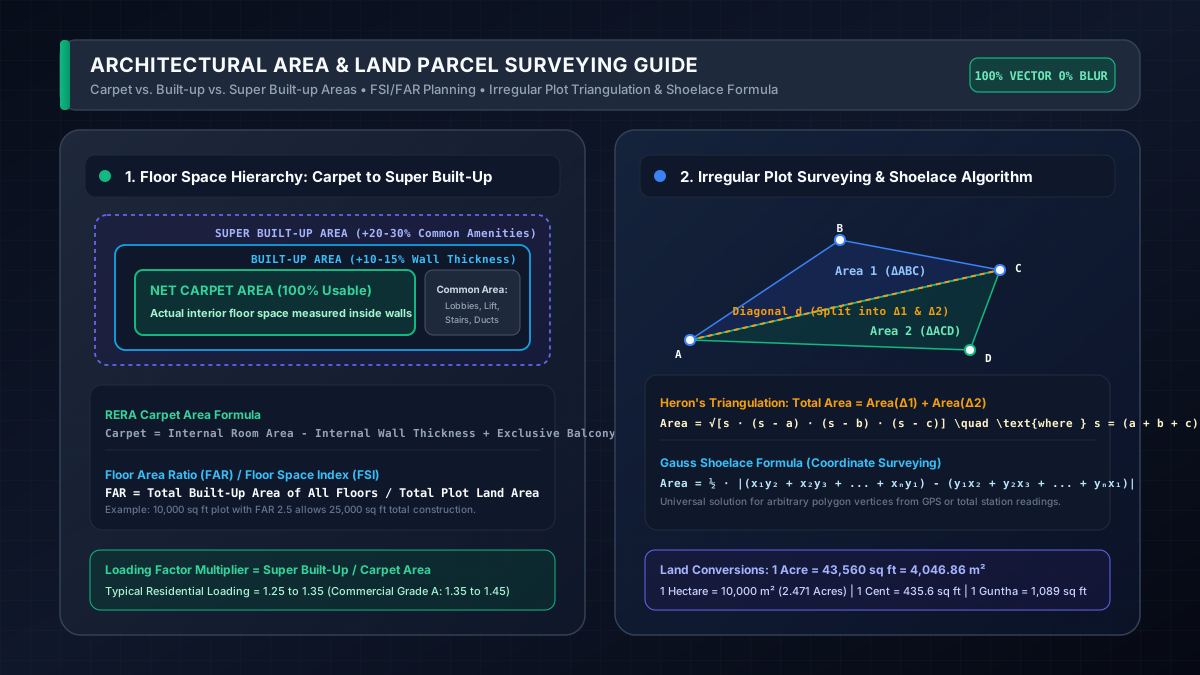
1. The Architectural Hierarchy: Carpet Area, Built-Up Area & Super Built-Up Area
In architectural drafting and real estate law (such as the Real Estate Regulatory Authority, RERA), square footage is classified into three nested concentric categories to prevent deceptive marketing and ensure structural transparency:
- Carpet Area: The net usable floor space of an apartment or commercial unit measured strictly between inner wall surfaces. It represents the space where a carpet could literally be laid, excluding the area occupied by external walls, common corridors, elevator shafts, or public lobbies. Under RERA guidelines, only exclusive private balconies and verandas directly accessed by the occupant may be specified alongside carpet area.
- Built-Up (Plinth) Area: The total gross footprint enclosed by the outer perimeter walls of the private unit. It equals the carpet area plus the cross-sectional area occupied by external and internal dividing walls, structural columns, and half-share of party walls shared with adjacent units. Typically:Built-Up Area = Carpet Area · (1.10 to 1.15) \quad [adds 10% to 15% for wall thickness]
- Super Built-Up (Saleable) Area: The comprehensive commercial billing footprint charged to buyers. It includes the built-up area plus a proportionate share of all common building amenities (entrance lobbies, stairwells, elevator banks, electrical transformer rooms, pump houses, and security corridors).Super Built-Up Area = Built-Up Area · (1.20 to 1.35)
2. Floor Space Index (FSI) & Floor Area Ratio (FAR) Zoning Regulations
Municipal urban planning authorities regulate population density and infrastructure load through the Floor Area Ratio (FAR), interchangeably referred to in Asian and European jurisdictions as the Floor Space Index (FSI). FAR represents the ratio of total combined built-up floor area across all vertical stories to the gross horizontal surface area of the land parcel:
FAR = (Total Gross Floor Area of All Stories) / (Gross Plot Land Area)
For example, on a 10,000 square foot parcel governed by an FAR of 2.5, a developer is legally permitted to construct up to 25,000 square feet of total enclosed building space. This can be configured as a 5-story building occupying 5,000 sq ft per floor (50% ground coverage) or a 10-story tower occupying 2,500 sq ft per floor (25% ground coverage), leaving 75% of the parcel for open green space, setbacks, and storm retention.
3. Irregular Land Parcel Surveying: Heron's Triangulation Method
Rarely are natural land plots perfectly rectangular. Most real-world residential lots and agricultural parcels are irregular quadrilaterals with unequal sides and non-90° corners. Because the area of an irregular four-sided shape cannot be solved from side lengths alone without angular data, licensed land surveyors measure a dividing diagonal tie line (d) to decompose the quadrilateral into two distinct triangles (ΔABC and ΔACD).
Each triangle is then solved using Heron of Alexandria's classical geometric formula:
s = (a + b + d) / 2 → Area = √(s · (s - a) · (s - b) · (s - d))
Summing the areas of both triangles yields the exact boundary surface area without requiring expensive theodolite angle verification.
4. Coordinate Geodesy: The Gauss Shoelace Algorithm for Arbitrary Polygons
For complex civil survey plots with 5 or more vertices, electronic Total Stations and GPS RTK rovers output spatial coordinates (x_i, y_i) in local northing and easting planes. The Gauss Shoelace Formula (Surveyor's Formula) computes the exact 2D signed polygonal area by evaluating alternating cross products of consecutive boundary vertices:
Area = 0.5 · |(x₁y₂ + x₂y₃ + ... + xₙy₁) - (y₁x₂ + y₂x₃ + ... + yₙx₁)|
This algorithm is numerically stable, handles concave boundaries, and forms the mathematical backbone of modern Geographical Information Systems (GIS) and CAD parcel mapping.
5. Regional Land Measurement Units & Surveying Conversion Matrix
Global civil construction requires navigating diverse historical and statutory land measurement standards:
- International Standard: 1 Hectare = 10,000 m² = 2.47105 Acres = 107,639 sq ft.
- Imperial Acre: 1 Acre = 43,560 sq ft = 4,840 sq yards = 4,046.86 m².
- South Asian Units: 1 Guntha = 1,089 sq ft (33 ft × 33 ft); 40 Gunthas = 1 Acre. 1 Cent = 435.6 sq ft (1/100th of an Acre).
- Northern India & Pakistan: 1 Bigha typically equals 20 Biswas (~27,000 sq ft in Pucca Bigha down to ~14,400 sq ft in Kacha Bigha). 1 Marla = 225 or 272 sq ft; 20 Marlas = 1 Kanal.